


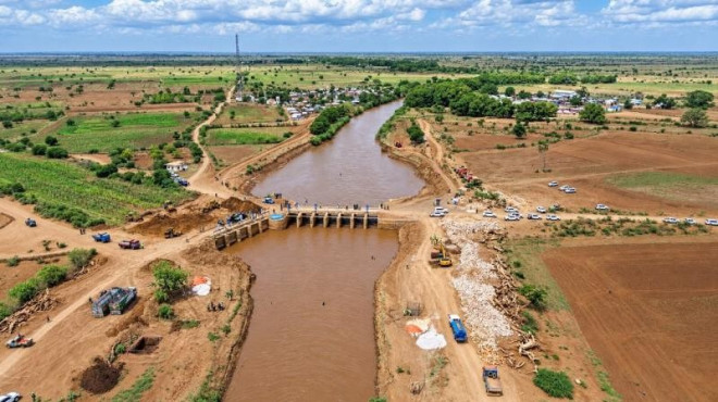
Water levels in the Shabelle River in Jowhar, the capital of Middle Shabelle region, have exceeded the high-risk threshold, raising concerns about potential flooding in nearby villages, farmland and residential areas.
According to data from the Somalia Water and Land Information Management (SWALIM) programme, operated by the United Nations Food and Agriculture Organization (FAO), in collaboration with the Somali Disaster Management Agency, the river reached approximately 5.38 metres on October 14.
The level exceeded the high-risk threshold of 5.25 metres and approached the river’s reported channel capacity of 5.50 metres, heightening concerns over possible flooding if water levels continue to rise.
Weak Embankments Increase Flood Risks
Reports indicate that water is flowing through weak sections and breaches in earthen embankments along the river corridor between Jowhar and Balcad.
Further deterioration of these embankments could expose nearby communities and agricultural land to flooding, threatening homes, crops and livelihoods in an area where many households depend on farming and livestock.
The concerns come amid rainfall forecasts of between 50 and 100 millimetres in parts of Hiiraan and Middle Shabelle regions from October 13 to 19, with higher amounts possible in some locations.
Humanitarian Concerns Mount
Potential flooding could damage crops, kill livestock, destroy roads and other infrastructure, disrupt humanitarian assistance and force residents to leave vulnerable communities.
The risks are particularly concerning as Somalia enters the Deyr rainy season, when seasonal rainfall can increase river levels and flooding risks in riverine areas.
Communities already facing food insecurity and livelihood challenges could experience further hardship if flooding damages agricultural production and disrupts access to essential services.
Authorities Urged to Strengthen Preparedness
Recommended measures include reinforcing vulnerable river embankments, closely monitoring water levels, identifying evacuation routes and preparing to move residents, livestock and essential food supplies to higher ground when necessary.
Coordination among local authorities, the Somali Disaster Management Agency and humanitarian partners will be important to support early warnings, emergency preparedness and timely assistance for communities at risk.
With the river already above its high-risk threshold and further rainfall forecast during the reporting period, continued monitoring and early action remain essential to reducing potential casualties, property damage and livelihood losses.

